 -
Bastides bienvenue :
-
-
.
-
Villes Neuves
-
- en EUROPE
:
-
Présentation générale
-
France
-
Espagne
-
Grande Bretagne
-
Italie
-
Pologne
-
Portugal
-
Suisse
-
Scandinavie :
-Finlande
-
Norvège -
- .
- hors d'EUROPE,
-
Amérique
-
Afrique
-
Asie
- .
-
Bastides médiévales:
- 1-
tableau des "modèles"
- 2- ..Libourne.
..Monpazier..Monflanquin.
- ..Vianne..Villeneuve/Lot
- Bastides
Gironde.
- .
- *
-
Définition de "Bastide",
-
leurs caractéristiques,
-
leurs Chartes.
-
Le Tracé orthogonal,
-
la Place,
-
la Halle,
-
les Maisons,
-
les Cornières un problème,
-
les Andrones,
-
L'église
-
les Remparts : avec ou sans.
-
Chateau : avec ou sans
-
Puits et ponts
-
Bastides Modèles.
-
Contexte historique.
- .
-
Présentation par :
-
Cartographie
-
Musée des Bastides,
-
Centre Etude Bastides,
-
Bibliographie,
-
Glossaire,
-
Toponymie
- .
-
Bastides Répertoire
-
par fondateurs:
-
Cisterciens
-
par départements,
-
sur sites internet
-
par bastides :
-
A à M
-
N
à V
-
par Thèmes
- .
-
L'orthogonalité :
- dans l'Antiquité,
-
dans la théorie.
- dans les arts
-
- *
-
Annexes sur :
-
les villes en étoile,
-
les "circulades",
-
Sauvetés et castelnaus
-
-
**
-
Recherche d'une vue aérienne
-
de ville sur "google earth"
-
-
-
Recherche : Interreg
-
Université de Tokyo
|
|
|
Odo Georges |
|
Site traduit en : |
|
|
|
- .


- Plan orthogonal, en damier,
hyppodamien
| |
Villes Neuves
en
Grande Bretagne
|
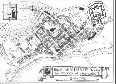
- Conwy S
S
|
- Caernafon
S
|
- Beaumaris
S
|
- Winchelsea
S
-
|
- Londres : les "estates"
lotissements autour d'un square
|
- .
|
Page tirée de
http://www.qub.ac.uk/urban_mapping/index.htm |
 |
|
|
|
|
Welcome to the homepage of the Mapping the Medieval Urban
Landscape Project
“Mapping the Medieval Urban Landscape” is a two-year research
project funded by the Arts and Humanities Research Board (AHRB).
The project was completed at the end of May 2005. The results of
the project are currently in preparation. A multimedia teaching
package will soon be available via the Archaeology Data Service
(ADS) website. An academic monograph is also in preparation.
The project aims to answer questions about the design and
planning of towns in the middle ages. To do this requires
careful study of the surviving layouts of medieval towns,
looking in particular at their shape and form, and to this end
the project is focused on new towns founded by King Edward I in
the late 1200s. Twelve of Edward’s towns have been selected for
close scrutiny. One is in England while the other 11 are in
Wales. (Click
here
for more information on the study towns).
The project came about to try to further our understanding of
the processes that created urban landscapes in the middle ages.
Conventional historical records do not reveal much about this,
and so it is necessary to look at the plans of the towns
themselves to map out how they came into being. This work is
important as the middle ages is the key period of European
urbanisation, when many towns and cities were established and
prospered. Indeed, much of the urban network and heritage of
Europe today is the result of our medieval ancestors. To
recognise and appreciate this legacy we need to study these
towns and cities (Click
here
for more on the project).
|
 |
|
|
 |
 |
|
|
|
|
|
|
Designed and maintained by Dr Steven Trick. Content by
project team.
Last updated 29th August 2005
|
|
|
http://antiquity.ac.uk/ProjGall/lilley/index.html |
Previous Page
Back to Project
GalleryAntiquity Vol 79 No 303 March 2005 Article
number 79003
Mapping medieval urban landscapes: The design and planning of Edward
I's new towns of England and Wales
| The towns and cities of medieval
Europe have long attracted scholarly attention but still
unanswered questions remain about the processes of design and
planning that shaped urban landscapes during the middle ages (Lilley
2002). With funding from the Arts and Humanities Research Board,
a two-year research project based at Queen's University Belfast
was set up in 2003 specifically to explore how a group of 'new
towns' in England and Wales were established under the authority
of King Edward I between 1277 and 1307 (Figure 1). The main aim
of the project is to reconstruct in 3D map-form the likely
original layout of these new towns and to use this as a way of
engaging with the original design ideas they reflect. To do this,
rather than employing existing paper-based methodologies (eg.
Slater 1987, Baker et al. 1992, Lilley 2000), the project
has combined spatial data sources in a Geographical Information
System (GIS), and in this respect offers a new direction for
those mapping medieval urban landscapes. Three particular
outputs of this work are highlighted here. |

Figure 1. Location map of study
towns and dates of foundation. Click to enlarge. |
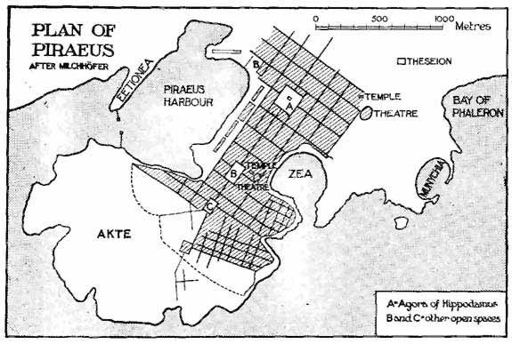
Figure 2. Beaumaris and Conwy
compared. Click to enlarge. |
Surviving medieval built forms
provide unique access to the minds of those who were responsible
for their design and planning (cf. Friedman 1988, Lilley
2001). Edward I's new towns have relatively good historical
documentation right from the start (see Beresford 1967, Soulsby
1983), and this, together with their reasonably intact medieval
urban layouts, makes them a suitable focus for study to tell us
about the practices and processes that originally created them.
As Conzen (1968) has argued, modern-day large-scale mapping
represents a ready source of information on the layout of
medieval towns, showing patterns of streets and plots that are
historically and archaeologically meaningful, as once set in
place these features have a tendency to survive over long
periods of time, making the town's morphology a 'palimpsest', a
record of its own evolution (Lilley 2000). Using first edition
Ordnance Survey 1:2500 plans of the late-nineteenth century,
street and plot patterns for each of the study towns were
digitised in a GIS software package (ArcGIS), allowing, for the
first time, the form of Edward's new towns to be compared at the
same scale, and their morphologies studied in detail in terms of
their street and plot patterns, and relative positions of
castles, markets and churches. This reveals design similarities
between towns, for example Conwy and Beaumaris (Figure 2). Such
comparisons are particularly easy to perform in GIS, and help to
formulate ideas about whether common practices and practitioners
had created them. At Conwy and Beaumaris, the king's principal
architect in Wales, Master James of St George, took a lead role
in constructing their respective castles (see Taylor 1986),
raising the possibility that he (or one of his men) was also
responsible for creating their similar town-plans. |
| To explore further the meanings
of such morphological similarities between Edward's new towns
requires 'reconstructive mapping' where an attempt is made to
show their urban layout at the time they were first created.
This is done through mapping documentary and archaeological
data, and combining it with the morphologies of the towns as
revealed by historic maps; all of which is done within GIS. The
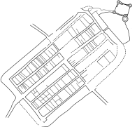
results of this are shown here for Rhuddlan, established in
summer 1277, and one of the earliest of Edward's new towns in
north Wales (Figure 3). The street and plot layouts are those
taken from the Ordnance Survey 1:2500 first edition plan (and
cross-checked with earlier archival maps of 1756, 1780, 1810 and
1839). Archaeological data is taken from both published and
unpublished surveys, evaluations and excavations (eg. Manley
1985, Quinnell et al. 1994). The two data sets - the
historic cartography and medieval archaeology - are both
georeferenced using spatial co-ordinates derived from
field-survey work conducted in the town by the project team
using differential GPS. The reconstructed map of Rhuddlan shows
the layout of the town c. 1300, with its arrangement of
streets and earthen bank-and-ditch defences. The original
circuit of these is uncertain but by extrapolating the lines of
the known defences, and relating them to plot patterns evident
in the town plan, the line of the town's defensive circuit can
be conjectured. To help visualise the layout of Edward's
Rhuddlan, and to explore more how its plan-features were placed
within the local landscape, elevational data (NEXTMap) is used
to create a 3D model (Figure 4). This then clearly shows how
Edward's new town lay at the end of a river terrace above the
Clwyd, positioned at its lowest medieval bridging-point and
arranged to make most use of the flattest ground. The resulting
town-plan is a skewed quadrilateral shape. |

Figure 3. Rhuddlan reconstructed
town plan c.1300. Click to enlarge.
|

Figure 4. Edwardian Rhuddlan
visualised as a 3D model. Click to enlarge.
|
Reconstructive mapping offers a
window onto the landscapes of Edward's new towns but to get back
to the planning processes that created them requires some
'reverse engineering' of their urban layouts. Again GIS helps
with this and is demonstrated here for two reasonably
well-documented towns where there is contemporary historical
evidence (dating from shortly after their foundations) for the
original size of their respective building plots. In the case of
Winchelsea, in East Sussex, a list of properties from 1292
records the areal sizes of the plots within the town's grid of
street blocks, making it possible to compare medieval surveyors
measurements with those made by the project team using
differential GPS equipment (Figure 5). What this has shown is
that the surveyors of 1292 were highly accurate in their work (Lilley
et al. 2005). For Caernarfon, in north Wales, a document
of 1298 records that building plots in the town were sixty feet
wide and eighty feet deep. Using the georectified plan of the
town's streets and plots it is possible to explore how well the
documented plot-size relates to actual plots on the ground
(Figure 6). Once again there is good coincidence between
medieval and modern plot measures, though in this case the 'ideal'
plot size seems to have required some adaptation to fit
comfortably into the street-block in the north-west part of the
town (cf. Slater 1987). Both exercises demonstrate the
longevity of plot and street layouts, from the later middle ages
through to the modern day. |
| The project is still ongoing but
already, through a combination of historical spatial data
sources, mapped and analysed using GIS, it has begun to reveal
how Edward's new towns were designed and planned over 600 years
ago. The approach taken here is novel as far as studies of
medieval urban landscapes are concerned, and is demonstrating
the methodological advantages that spatial technologies offer in
this kind of work. To date, a spatial database exists for each
of the thirteen towns, including georeferenced cartographic and
archaeological data. This data is being used currently to
conduct: (1) detailed metric analyses of the towns'
morphologies; (2) reconstructive mapping and analysis of the
type outlined above; (3) 3D visualisation of Edward's new towns,
and (4) the development of an online resource. The databases
will be deposited with the Arts and Humanities Data Service
(AHDS) at the end of the project, and as well as having academic
uses the information they contain has local development control
applications, for example in terms of predicting zones of
archaeological potential. (For further information on the
project see
http://www.qub.ac.uk/urban_mapping). |

Figure 5. Winchelsea street blocks,
c.1290, based upon field survey and 1292 rental |

Figure 6. Caernarfon 'ideal' plots
overlaying actual plot layout |
References
 | BAKER, N.J., H. DALWOOD, R.A. HOLT, C.F. MUNDY & G.
TAYLOR. 1992. From Roman to medieval Worcester: development
and planning in the Anglo-Saxon city. Antiquity 66:
65-74.
|
| BERESFORD, M.W. 1967. New Towns of the Middle Ages.
Town plantation in England, Wales and Gascony. London:
Lutterworth.
|
| FRIEDMAN, D. 1988. Florentine New Towns. Urban design
in the late middle ages. London: MIT Press.
|
| LILLEY, K.D. 2000. Mapping the medieval city: plan
analysis and urban history. Urban History 27: 5-30.
|
| LILLEY, K.D. 2001. Urban planning and the design of
towns in the middle ages: the Earls of Devon and their 'new
towns'. Planning Perspectives 16: 1-24.
|
| LILLEY, K.D. 2002. Urban Life in the Middle Ages,
1000-1450. London: Palgrave.
|
| LILLEY, K.D., C. LLOYD, S. TRICK & C. GRAHAM. 2005.
Mapping medieval urban landscapes using GIS and GPS.
Urban Morphology 9 (forthcoming).
|
| MANLEY, J. 1985. Salvage Excavations at Lôn Hylas,
Rhuddlan, Clwyd: ditches of the Roman and Medieval periods.
Archaeologica Cambrensis 134: 230-235.
|
| QUINNELL, H., M.R. BLOCKLEY & P. BERRIDGE. 1994.
Excavations at Rhuddlan, Clwyd: 1969 - 73 Mesolithic to
Medieval. CBA Research Report 95. York: Council for
British Archaeology.
|
| SLATER, T.R. 1987. Ideal and reality in English
episcopal medieval town planning. Transactions of the
Institute of British Geographers New Series 12(2):
191-203.
|
| SOULSBY, I. 1983. The Towns of Medieval Wales.
Chichester: Phillimore.
|
| TAYLOR, A. 1986. The Welsh Castles of Edward I.
London: Hambledon Press. |
|

Lilley, Lloyd, Trick: School of Geography, Queen's
University Belfast, Northern Ireland, UK.
Back to Top
|
Previous Page
Home |
Online Archive |
Project Gallery
| FAQs
Letters to the
Editor | Events
and Announcements |
Reviews |
TAG
To cite this page use: http://antiquity.ac.uk/ProjGall/lilley/index.html
|
.
|


)
)
)
)
)
)